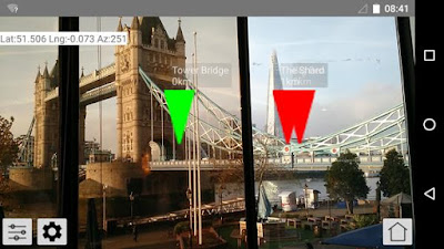
I spent the latest DadenU day doing some more work on the AR app I started last time. Like the recent OS feature this is a geospatial AR app, so it puts markers in your smartphone viewscreen which align with real world objects. As you pan around you see different objects, and if you move to a new location all the markers track the objects they are pointing at.
The driver for the project is a personal "need" to have such an app to support battlefield walks, but we can also see some commercial potential for it, as well as more formally exploring the battlefield tours angel with the Battlefields Trust of which I'm a member.
In the latest session I focussed on bring the data in from the web, rather than having it hard coded within the app. This meant developing a JSON format for the data, doing a fetch by web service request, and then feeding the data to the existing plotting routine.
Getting my head around JSON took a fair amount of time, I much prefer, XML, and most of the rest was fairly trivial. Where I got stuck at the end though was creating a dynamic drop down of the available locations based on the files on the web server - will have to ask one of our pros how to do that!
Over the next couple of months I hope to work it up to a full blown demo based on a real battlefield, and then we'll see where we can take it.

